Now then, right South of Melbourne lies the beautiful Phillip Island, home of the Penguin Parade (already discussed), and a corker of a koala sanctuary (lot of my mates there). Okie found a superb winery, - The Purple Hen - but I'm a beer koala myself, along with the ol' gum- leaves. There's lots of bonzer little towns such as Cowes and Rhyl, and a Grand Prix circuit for motor sports - bloody noisy though - a koala can't get his rest when those drongoes are playing.! Okie quite liked the very Western tip of Phillip Island - the area known as the Nobbies. More spectacular scenery!The first image shows a classic view of Seal Island - the very tip of Phillip Island with almost stepping stone rocks and a flat topped little hill. Another image of Seal Rocks taken from further along the boardwalk is a 3 image HDR composite, showing some neat coloured detail of the cliff face, normally seen as a black mass in a conventional photograph. Good on you, Okie, for that cracker.


This third image is one of Okie's experimental works - he's always willing to give it a burl! This is a long exposure shot of one of the massive rocky outcrops being pounded by waves; what a whopper, Okie!

Now then my little possums - something astonishing. Fair dinkum, you've not seen anything like this! To the east of Phillip Island lies the massive area known as Gippsland - an area that includes one of the wonders of Victoria - The Ninety Mile Beach and Lakes Entrance. I know that's two wonders, but we don't like to over egg things in Oz. Before looking at the next three images, some explanation is needed. Stretching for about 90 miles along the south coast of Gippsland is this sandy beach; behind the beach is a lake, and the lake is full of islands and promontories so the main lake is like lots of smaller interconnected lakes. There was a single natural channel that connected the lake to the ocean, but it was difficult to navigate. So, a man-made entrance to the lake was built starting in about 1869. And the town that grew up about this is now called Lakes Entrance. You can read all about it here ==> www.smh.com.au/travel/travel-f….
The first of these images is a 4 shot pano taken from Jemmy's Point , a hill above Lakes Entrance. You can see the channel in the distance just to the right of the left-hand side behind a boat (a dredger). The ocean is the dark blue line, and the lakes spread out left and right in the foreground. The second shot is a zoom shot to give a closer view of the entrance with the turbulence of where the ocean and the lake water meet clearly visible. The third shot is from right down at the Entrance, looking at the ocean waves crashing onto the right hand pier.


The Ninety Mile Beach is spectacular not only for its scenery but also for the wind that whips up the sand to scour your skin when you try to stroll along, and for the roar of the waves crashing on shore.

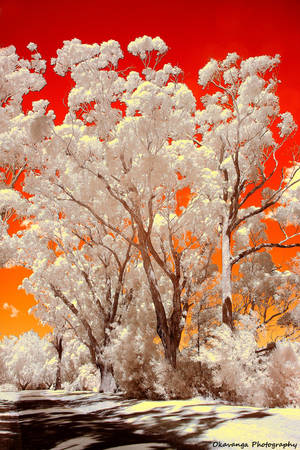
Further East from Lakes Entrance, you come to the once mighty Snowy River, an image of the tranquil lower reaches is seen in the next shot. While most of the flow of the river has now been lost to irrigation and hydroelectric schemes in the mountains of its origin, the Snowy River (beloved by Okie's geography teachers in the 1960's) is still capable of causing devastating floods in this region. Fortunately, we koalas live up in the trees, so we're not so affected. Some such trees are shown in the next image - an infrared complete with the Okavanga Effect.


Finally, even further East, come to Cape Conran, a wilderness area of immense natural beauty and dramatic rocky shores.


That's all for now, folks. I'm off to eat me a dog's eye, and to crack a tinny or two!
Cheers
Digger (and Okie)!
Skin by WickedIllusionArt modified by Okavanga
